India is a nation defined by its immense cultural diversity and rich historical heritage, currently comprising 28 states and 8 union territories. As the 7th largest country by land area and the world's 2nd most populous nation, its sheer scale is truly remarkable. From the sprawling deserts of the west to the densely populated plains of the north, understanding India's administrative geography is essential. This guide explores the largest states in India by both land area and population to provide you with the most accurate, up-to-date information.
Largest to Smallest States in India
Understanding the hierarchy of India's administrative divisions—including the largest and smallest states and union territories—is a common query for students and geography enthusiasts alike. India is composed of 28 states and 8 union territories in India. Rajasthan holds the title of the largest state by area, covering 342,239 Km2, followed by Madhya Pradesh and Maharashtra. Conversely, Uttar Pradesh remains the most populated state in India, followed by Maharashtra and Bihar. Below, we detail the complete landscape of Indian states and territories.
Largest State in India (Area-wise)
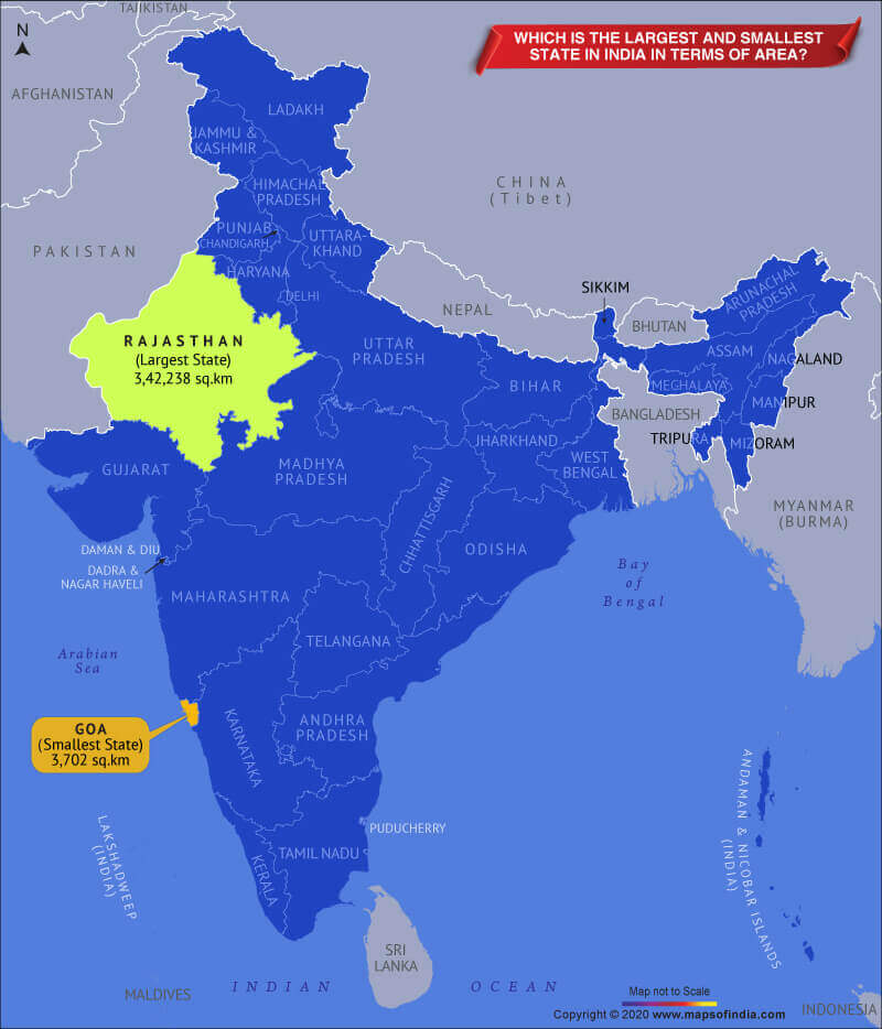
Rajasthan is the largest state in India in terms of area, spanning an expansive 342,239 km². According to the 2011 Census, the state is home to a population of 68,548,437. Geographically located in northwestern India, its capital, Jaipur, is famously known as the "Pink City." At the other end of the spectrum, Goa is the smallest state in India, covering just 3,702 km². The detailed breakdown of states by area is provided below:
| S.No. | State Name | Area (km²) |
| 1 | Rajasthan | 342,239 |
| 2 | Madhya Pradesh | 308,245 |
| 3 | Maharashtra | 307,713 |
| 4 | Uttar Pradesh | 240,928 |
| 5 | Gujarat | 196,024 |
| 6 | Karnataka | 191,791 |
| 7 | Andhra Pradesh | 162,968 |
| 8 | Odisha | 155,707 |
| 9 | Chhattisgarh | 135,191 |
| 10 | Tamil Nadu | 130,058 |
| 11 | Telangana | 112,077 |
| 12 | Bihar | 94,163 |
| 13 | West Bengal | 88,752 |
| 14 | Arunachal Pradesh | 83,743 |
| 15 | Jharkhand | 79,714 |
| 16 | Assam | 78,438 |
| 17 | Himachal Pradesh | 55,673 |
| 18 | Uttarakhand | 53,483 |
| 19 | Punjab | 50,362 |
| 20 | Haryana | 44,212 |
| 21 | Kerala | 38,863 |
| 22 | Meghalaya | 22,429 |
| 23 | Manipur | 22,327 |
| 24 | Mizoram | 21,081 |
| 25 | Nagaland | 16,579 |
| 26 | Tripura | 10,486 |
| 27 | Sikkim | 7,096 |
| 28 | Goa | 3,702 |
Largest Union Territory in India (Area-wise)
Jammu and Kashmir is the largest union territory in India in terms of area, encompassing approximately 125,535 km2. Below is the comprehensive list of union territories ranked by their geographical size:
| S. No. | Union Territory Name | Area (km²) |
| 1 | Jammu and Kashmir | 125,535 |
| 2 | Ladakh | 96,701 |
| 3 | Andaman and Nicobar Islands | 8,249 |
| 4 | Delhi | 1,484 |
| 5 | Dadra and Nagar Haveli & Daman and Diu | 603 |
| 6 | Puducherry | 479 |
| 7 | Chandigarh | 114 |
| 8 | Lakshadweep | 32.62 |
Updated List of State CMs & Governors 2026: Read Now
Largest State in India (Map)
Largest State in India by Population
Uttar Pradesh is India's most populous state, while Bihar reports the highest population density. Based on 2011 Census data, Uttar Pradesh reached a population of 199,812,341, spread across its 240,928 km2 of land. Sikkim currently holds the title of the least populated state. You can find the state-wise population rankings listed below:
| S. No. | State Name | Population (As per Census 2011) |
| 1 | Uttar Pradesh | 199,812,341 |
| 2 | Maharashtra | 112,374,333 |
| 3 | Bihar | 104,099,452 |
| 4 | West Bengal | 91,276,115 |
| 5 | Andhra Pradesh | 84,580,777 |
| 6 | Madhya Pradesh | 72,626,809 |
| 7 | Tamil Nadu | 72,147,030 |
| 8 | Rajasthan | 68,548,437 |
| 9 | Karnataka | 61,095,297 |
| 10 | Gujarat | 60,439,692 |
| 11 | Orissa | 41,974,218 |
| 12 | Kerala | 33,406,061 |
| 13 | Jharkhand | 32,988,134 |
| 14 | Assam | 31,205,576 |
| 15 | Punjab | 27,743,338 |
| 16 | Chhattisgarh | 25,545,198 |
| 17 | Haryana | 25,351,462 |
| 20 | Uttarakhand | 10,086,292 |
| 21 | Himachal Pradesh | 6,864,602 |
| 22 | Tripura | 3,673,917 |
| 23 | Meghalaya | 2,966,889 |
| 24 | Manipur | 2,855,794 |
| 25 | Nagaland | 1,978,502 |
| 26 | Goa | 1,458,545 |
| 27 | Arunachal Pradesh | 1,383,727 |
| 29 | Mizoram | 1,097,206 |
| 31 | Sikkim | 610,577 |
Largest Union Territory in India by Population
Delhi, the capital of India, is the most populous union territory. As recorded in the 2011 Census, Delhi's population stood at 16,787,941. The detailed population list for all territories follows below:
| S. No. | UT Name | Population (as per 2011 Census) |
| 1 | Delhi | 16,787,941 |
| 2, 3 | Jammu and Kashmir + Ladakh | 12,541,302 |
| 4 | Puducherry | 1,247,953 |
| 5 | Chandigarh | 1,055,450 |
| 6 | Dadra and Nagar Haveli & Daman and Diu | 5,86,956 |
| 7 | Andaman and Nicobar Islands | 380,581 |
| 8 | Lakshadweep | 64,473 |
View the Complete List of Indian States and Capitals
Purpose of this Article
Many citizens are often unfamiliar with the largest and smallest states and union territories in India. Having a clear grasp of our national geography and political boundaries is a key responsibility of any informed citizen. Furthermore, these facts are frequently tested in competitive examinations, including the SSC and various state-level civil service exams. Aspiring government employees should ensure they are well-versed in these statistics.
General Knowledge (GK) Guide 2026
Largest State in India- FAQs
Ans. Uttar Pradesh is the most populous state in India, with a recorded population of 199,812,341 according to the 2011 Census.
Ans. Rajasthan is the largest state in India by land area, spanning 342,239 km².
Ans. Sikkim is the least populated state in India, with a total population of 610,577.
Ans. Jammu & Kashmir is the largest union territory in India by area, covering approximately 125,535 km².
Ans. Goa is the smallest state in India, with a total geographical area of 3,702 km².
Ans. Bihar is the most densely populated state with 1,106 persons per sq.km, followed by West Bengal (1,028) and Kerala (860).
Recommended Reads
- Rajasthan Safai Karmchari Bharti 2026 Notification Out for 24,752 Vacancies
- JKSSB Jail Warder Recruitment 2026 Notification Out for 288 Vacancies
- Assam D.El.Ed PET Merit List & Result 2026 Out (All Districts): Download PDF & Check Marks
- APCOB Staff Assistant Syllabus 2026 & Exam Pattern: Subject-Wise Topics
- MPSC Meghalaya LDA Syllabus 2026 & Exam Pattern: Subject-Wise Topics
- HP SET Result 2026 Released, Subject-Wise Merit List PDF @hppsc.hp.gov.in
Never miss another exam update!
Get the fastest exam results, recruitment news, and educational guides delivered directly to your phone.